Documents:
Development Plan Overlay schedule 6
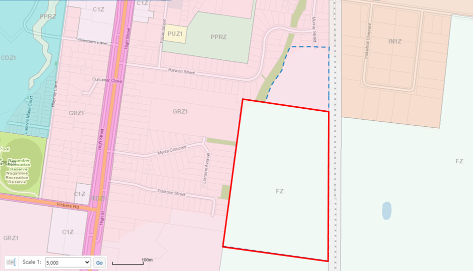
Planning Scheme Amendment C85 – Murray Street, Nagambie
Planning Scheme Amendment C85 is a proponent-led planning scheme amendment that seeks to rezone the land at Lot B PS815393 Murray Street, Nagambie to allow for the possibility of residential subdivision. The land to be rezoned is better identified as the undeveloped land directly south of Murray Street in Nagambie.
The amendment proposes to rezone this land from Farming Zone (FZ) to General Residential Zone (GRZ) and inserts the Development Plan Overlay (Schedule 6). The amendment will facilitate the future subdivision of the land to provide additional residential land for housing and other residentially related land uses and for the extension of Murray Street. The Development Plan Overlay allows Council to consider the subdivisional layout for the entire piece of land and provides better guidance to the community and developer on what information will be required when it comes time for subdivision.
The hyperlink to ‘Development Plan Overlay schedule 6’ at the top of this page has a list of requirements that any future application for a subdivision will need to satisfy Council’s requirements which include the consideration of:
- Public open space;
- Protection of residents from bushfire;
- Native vegetation;
- Drainage;
- Traffic;
Is there a subdivision plan for viewing?
At this stage of the process there is no subdivision plan available to exhibit. The Development Plan Overlay schedule 6 identifies the requirement for several plans and reports to address the aforementioned items to be submitted with any planning application for subdivision. These plans will inform the final layout of the future subdivision and that is why we are unable to show a layout at this current stage.
What does the amendment do?
More specifically, the Amendment proposes to:
- Rezone the land at Murray Street, Nagambie Lot B, PS815393J from Farming Zone to General Residential 1 Zone, by amending Planning Scheme Map No. 22 of Strathbogie Planning Scheme, and
- Inserts a new site-specific Schedule to the Development Plan Overlay for “Nagambie South East”; and
- Amends Planning Scheme Map 22DPO
Exhibition
Exhibition is the time for the public, referral agencies and the prescribed ministers to be notified of the planning scheme amendment and to
The amendment will be on public exhibition from Thursday 7th September to Tuesday 10th October, 2023.
Council will be holding two drop in days at the Nagambie Lakes Regatta Centre on:
- Thursday, September 14 from 9am to 3pm; and
- Thursday, September 21 from 9am to 3pm
If you require assistance with the amendment or want to make an appointment to talk to a Strategic Planner please contact us either via info@strathbogie.vic.gov.au or 5795 0000.